European Solutions

European Solutions

Insurance, Financial Services and Real Estate

Our European insurance solution is featured in Czech insurance magazine Pojistný obzor (Insurance Horizon). Climate change is increasing the frequency of damage caused by natural catastrophes, particularly floods. The availability of accurate input data and modern modeling technology, as well as cloud deployment systems, simplifies and reduces the cost for insurance companies to underwrite flood risk. Published by Česká asociace pojišťoven (Czech Insurance Association) since 1922, Pojistný obzor (Insurance Horizon) provides a platform for insurance professionals to engage and learn about key topics in the domestic and foreign insurance markets.

Current trends in creation and use of flood maps by the insurance market

Insurance Products and Services

We offer subscriptions for multiple hazard maps, such as flood and other acute meteorological perils, as well as chronic climatic and geophysical perils. We also provide subscriptions for climate change-based hazard maps for flood and other chronic or acute perils.

We also offer (re)insurance analytics and services, such as bulk geocoding and address/parcel standardization, floaters redistribution, accumulation, choropleth maps (cartograms), portfolio analysis, elevation profile analysis, claim adjustment analytics and natural catastrophe and probable maximum loss modeling.

Flood Risk Map

Flood risk maps for river flood and pluvial flood

Aquarius Transparent

We combine software tools for risk assessment, insurance relevant data and reinsurance analytics and services into a single package. Aquarius RMA is our software application for risk management. It is available as an on-premise solution or a subscription-based cloud SaaS. It is offered as a full packaged web-based application for large clients in-house or operated by Intermap within a geographically distributed cloud environment.

Portfolio Analysis

Portfolio analysis

Data

  • Acute meteorological hazard, such as (extra-tropical) windstorm, hail, lightning, tornado, fire weather, wildfire, snow weight and tropical cyclone (hurricane)
  • Chronic climatic hazard, as drought, heat and precipitation stress
  • Geophysical hazard, as earthquake, landslide, volcano and tsunami
  • Climate change-based hazard maps for all types of flood as well as drought, heat and precipitation stress, fire weather, sea level rise and tropical cyclones
  • Address and parcel databases from publicly and commercially available sources
Accumulation Analysis

Accumulation analysis

Analytics

  • Automatic bulk geocoding & address/parcel standardization
  • Floaters redistribution analysis
  • Accumulation analysis
  • Portfolio analysis and choropleth maps (cartograms)
  • Elevation profile analysis
  • Multi-risk assessment and reporting with Risk Assistant, powered by AI
  • Claim adjustment analytics

RMA Web Services

RMA Web Services allow client workflows, such as policy management, underwriting, claim management systems or online insurance applications, to query risk information for a particular address or geo-coordinate location. RMA Web Services is available via API for integration with third-party solutions, with a predefined number of calls per month.

Insurance Consulting Services

Flood analysis

Flood analysis

CAT / PML Modeling. Stochastic modeling of possible maximum loss (PML) for flood using limits, deductibles, coinsurance, and multi-locations as well as custom vulnerability functions.

Manual Geocoding & Address / Parcel Standardization. Bulk geocoding of addresses or parcel numbers and their risk evaluation. This includes standardization and correction of typos, mistyped street names or postal codes, abbreviations and missing characters.

Flood Footprint Mapping. Custom mapping of flooded areas using airborne or UAV technologies.

General Insurance Consulting. Cost-benefit analysis, customer seminars and trainings, portfolio risk analysis, custom risk mapping, application support during catastrophic events, UAV-based risk and claim assessment.

Data Updates. Recurring or one-time updates of hazard map layers, address or parcel databases, and background maps.

Geocoding Solutions

Our Geocoding Solutions are subscription-based services for insurers, reinsurance brokers and reinsurers.

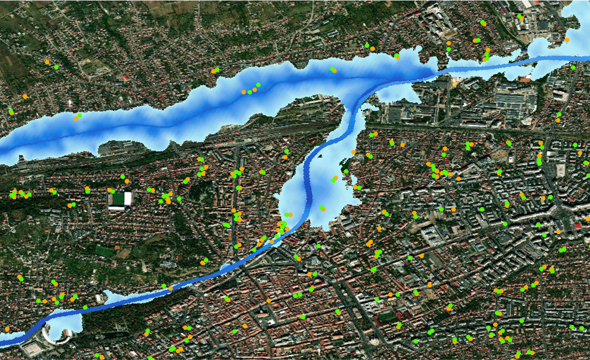
Example of flood hazard zones in Romania. Green dots represent correct location after batch geocoding process, orange dots represent original incorrect location. It is not uncommon for a property to be incorrectly categorized as outside a flood zone when it is actually located inside one, or vice versa.

Batch Assessment. Large portfolios are assessed for the purpose of reinsurance renewal, claim management or underwriting of portfolios from brokers or multi-locations. 

Automatic Bulk Geocoding & Risk Assessment. Automatically cleans data in batch and assigns the correct address, coordinates, and hazard zones based on Intermap’s or third party hazard maps. 

Polygon-Based (area or footprint) Risk Assessment. Risk evaluation for larger sites such as industrial areas, transport infrastructure, agricultural parcels or custom defined shapes.

Financial Services and Real Estate

Our data and analytics are available to our partners in financial services and real estate for use in property valuation applications. This includes risk information on flood, other acute or chronic meteorological perils, geophysical perils, as well as climate change-based forward looking risk information and multi-risk assessment.

Financial-Services-and-Real-Estate

Earthquake map (left) and wildfire map (right)

Partners

Supplier – These partners supply data that is integrated into our solutions and delivered to customers in the insurance, financial services and real estate markets.

Twinn

Value-Added Resellers – These partners combine Intermap data and analytics services with their solutions to address insurance, financial services, and real estate market specifics and client requirements.

DataligenceCreative DockFlycomMyNemoPluto - OltSynergy Reinsurance Services

Associations – These partners secure the interests of insurance, financial services, and real estate companies and help establish our position in the markets.

ČAP SLASPO

Clients

Major insurance, financial services, real estate groups and national players with operating entities in Central Eastern Europe use Intermap software, data and analytics services as packaged solutions or as a standalone delivery integrated with third-party solutions.

Banka CREDITASBNPP Paribas CardifČeská spořitelnaČMSSČPPČSOBČSOB pojišťovnaDirectERGOGeneraliHypoteční bankaKooperativaMaxima pojišťovnaMONETA Money BankPojišťovna VZPRaiffeisen stavební spořitelnaUNIQA